


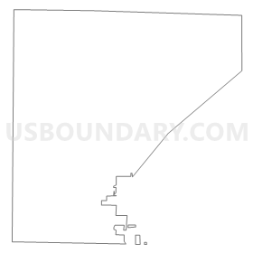
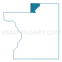
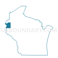
WEST SWEDEN - T 1 Voting District, Polk County, Wisconsin
About
Outline
Summary
| Unique Area Identifier | 696169 |
| Name | WEST SWEDEN - T 1 Voting District |
| County | Polk County |
| State | Wisconsin |
| Area (square miles) | 25.46 |
| Land Area (square miles) | 24.32 |
| Water Area (square miles) | 1.13 |
| % of Land Area | 95.55 |
| % of Water Area | 4.45 |
| Latitude of the Internal Point | 45.68727370 |
| Longtitude of the Internal Point | -92.48566450 |
Maps

Graphs
Select a template below for downloading or customizing gragh for WEST SWEDEN - T 1 Voting District, Polk County, Wisconsin


Neighbors
Neighoring Voting District (by Name) Neighboring Voting District on the Map
- CLAM FALLS - T 1 Voting District, Polk County, WI
- DANIELS - T 1 Voting District, Burnett County, WI
- Frederic - V 1 Voting District, Polk County, WI
- Frederic - V 2 Voting District, Polk County, WI
- LAKETOWN - T 1 Voting District, Polk County, WI
- LUCK - T 1 Voting District, Polk County, WI
- SIREN - T 1 Voting District, Burnett County, WI
- TRADE LAKE - T 1 Voting District, Burnett County, WI
- WEST SWEDEN - T 2 Voting District, Polk County, WI
- WOOD RIVER - T 2 Voting District, Burnett County, WI
Top 10 Neighboring County Subdivision (by Population) Neighboring County Subdivision on the Map
- Frederic village, Polk County, WI (1,137)
- Laketown town, Polk County, WI (961)
- Wood River town, Burnett County, WI (953)
- Siren town, Burnett County, WI (936)
- Luck town, Polk County, WI (930)
- Trade Lake town, Burnett County, WI (823)
- West Sweden town, Polk County, WI (699)
- Daniels town, Burnett County, WI (649)
- Clam Falls town, Polk County, WI (596)
Top 10 Neighboring Place (by Population) Neighboring Place on the Map
Top 10 Neighboring Unified School District (by Population) Neighboring Unified School District on the Map
- Grantsburg School District, WI (4,952)
- Frederic School District, WI (3,756)
- Siren School District, WI (3,047)
Top 10 Neighboring State Legislative District Lower Chamber (by Population) Neighboring State Legislative District Lower Chamber on the Map
Top 10 Neighboring State Legislative District Upper Chamber (by Population) Neighboring State Legislative District Upper Chamber on the Map
Top 10 Neighboring 111th Congressional District (by Population) Neighboring 111th Congressional District on the Map
Top 10 Neighboring Census Tract (by Population) Neighboring Census Tract on the Map
- Census Tract 9602, Polk County, WI (3,796)
- Census Tract 9601, Polk County, WI (3,722)
- Census Tract 9708, Burnett County, WI (2,329)
- Census Tract 9710, Burnett County, WI (1,927)